
The plan builds 4,400 homes by 2042 against a government need of 11,730. All 24 sites named, three added, three dropped. Consultation opens 2 October.
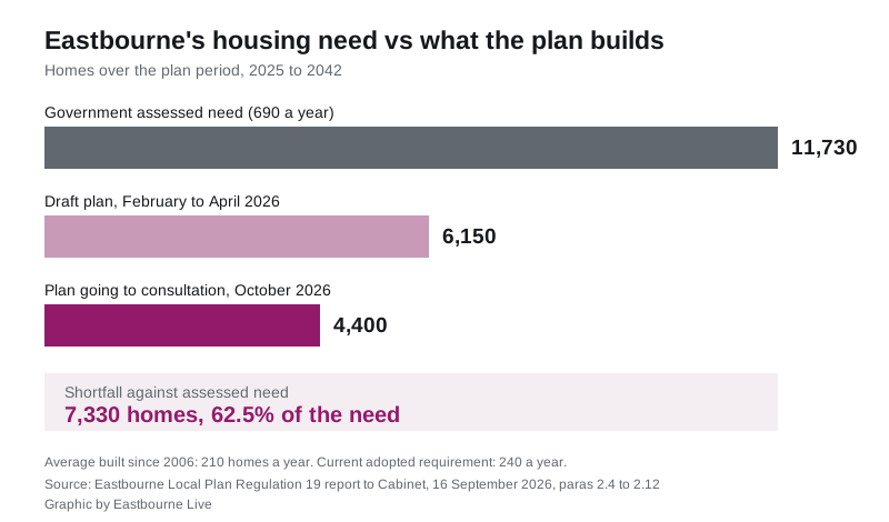
Eastbourne’s new Local Plan would build 4,400 homes by 2042. The government says the borough needs 11,730.
That gap of 7,330 homes, 62.5% of the assessed need, sits at the centre of the plan Cabinet endorsed on 16 September. It now goes to Full Council on 30 September, and if approved a six-week public consultation opens on Friday 2 October.
The council’s own report to Cabinet sets out the arithmetic the press release does not. Applying the government’s standard method, Eastbourne’s housing need is 690 homes a year, or 11,730 over the plan period. The plan instead sets what officers call a “capacity-based housing requirement” of 4,400 homes.
The target has been cut twice this year
The 4,400 figure is not the council’s first answer. At the previous consultation stage, held between February and April this year, the draft plan proposed 6,150 homes. Six months later that has been cut by 1,750.
The report describes the new number as representing “a significant shortfall against the identified housing need”.
Three numbers put the scale in context:
- 690 a year is the government’s assessed need
- 240 a year is the requirement in the council’s current adopted Core Strategy, set in 2013
- 210 a year is what Eastbourne has actually built, on average, since 2006
Delivery under the new plan would start lower still. The report anticipates 190 homes a year for the first five years, stepping up to 300 a year from 2032/33. Officers say the step reflects “the reality that strategic site allocations are unlikely to be delivered within the first five years following adoption of the Plan”.
Why the council says it cannot build more
Officers list the constraints: coastal, river and surface water flood risk, the functional floodplain at Eastbourne Park, a tightly drawn boundary with Wealden, part of the South Downs National Park inside the borough, and the sea to the south.
The council also has to show it asked the neighbours. Under the Duty to Co-operate it approached the other East Sussex authorities to see whether any of the unmet need could go elsewhere. The report records that those discussions “have concluded that our housing needs cannot be met in neighbouring and other East Sussex local authority areas”.
Officers’ conclusion is that “all opportunities for development or increasing densities within the planning authority area have been exhausted”.
Whether an inspector accepts that is the question the whole plan turns on. The soundness test in national policy asks first whether a plan is “positively prepared”, meaning it “seeks to meet the area’s objectively assessed needs”. This one meets 37.5% of them.
Where the homes would go
The plan finds 4,486 homes of supply between 2025 and 2042:
| Source of supply | Homes |
|---|---|
| Completed 2025/26 | 260 |
| Commitments (sites with permission) | 959 |
| Strategic site allocations | 2,060 |
| Non-strategic site allocations | 284 |
| Windfall (sites not yet identified) | 923 |
| Total supply | 4,486 |
A further 454 homes of “potential capacity on identified sites” and 200 through estate regeneration would take the theoretical total to 5,140.
The 2,060 homes in strategic allocations are spread across 24 named sites. The largest are land adjoining the railway station and the Enterprise Centre (200 homes), land north of Pevensey Bay Road in Langney (250), land adjacent to Royal Parade and Prince William Parade on the Seaside (230), and land off Harbour Quay at Sovereign Harbour (231).
The full list, with the neighbourhood each sits in:
| Ref | Site | Neighbourhood | Homes |
|---|---|---|---|
| SA01 | Land adjoining the Railway Station and the Enterprise Centre | Town Centre | 200 |
| SA02 | Former Debenhams, 152-170 Terminus Road | Town Centre | 60 |
| SA03 | Corner of Langney Road and Cavendish Place | Town Centre | 47 |
| SA05 | Former Curzon Cinema, Langney Road | Town Centre | 30 |
| SA06 | Land at 2-8 Saffrons Road | Town Centre | 28 |
| SA07 | Former Police Station, Grove Road | Town Centre | 50 |
| SA09 | Former Claremont Hotel, Grand Parade | Town Centre | 65 |
| SA10 | Whitley Bridge Yard | Seaside | 100 |
| SA11 | Land adjacent to Royal Parade and Prince William Parade | Seaside | 230 |
| SA12 | Land at East Sussex College, Kings Drive | Ocklynge and Rodmill | 130 |
| SA14 | Land at 2-4 Moy Avenue | Roselands and Bridgemere | 36 |
| SA16 | Land north of Pevensey Bay Road | Langney | 250 |
| SA17 | Summerdown Field, Compton Drive | Summerdown and Saffrons | 25 |
| SA18 | Aldro, Darley Road | Meads | 100 |
| SA19 | Queenwood, Darley Road | Meads | 30 |
| SA20 | Welkin, Carlisle Road | Meads | 56 |
| SA21 | New Field, Carlisle Road | Meads | 40 |
| SA22 | Land East of Carlisle Road | Meads | 42 |
| SA23 | Land North East of St Anthony’s Hill | St Anthonys and Langney Point | 35 |
| SA24 | Land off Harbour Quay | Sovereign Harbour | 231 |
| SA25 | Land adjacent to the Waterfront | Sovereign Harbour | 30 |
| SA26 | St Elizabeth’s Church, Victoria Drive | Ocklynge and Rodmill | 25 |
| SA27 | Former Railway Sidings, Tutts Barn Lane | Upperton | 120 |
| SA29 | St Andrews Prep School, Meads Street | Meads | 100 |
Meads carries six of the 24 sites, more than any other neighbourhood, for a combined 368 homes.
Three sites added, three dropped
Since the spring consultation the council has added three strategic sites. St Elizabeth’s Church on Victoria Drive was previously a non-strategic site for 10 homes and has been reassessed upwards to 25. The former railway sidings at Tutts Barn Lane in Upperton come in at 120 homes, and St Andrews Prep School on Meads Street at 100.
Three have come out:
- Former Law Courts, Old Orchard Road (30 homes), which now has planning permission and counts as a commitment instead. Work on those 30 council flats started in August.
- Land in East Langney Levels (150 homes), where further information no longer supports allocation
- Land at 38-40 Ashford Road (34 homes), for the same reason
The call for sites remains open. Officers describe the approach as leaving “no stone unturned”.
The deadline behind all of it
The timetable is tight and it is not the council’s choosing. The plan must be submitted to the Secretary of State by 31 December 2026 to be examined under the existing plan-making rules, and it will be judged against the December 2024 version of national planning policy rather than the current one.
That leaves this sequence:
- 30 September: Full Council decides whether to approve the plan for consultation, at 6pm in the Court Room at Eastbourne Town Hall
- 2 October: six-week consultation opens, in print at the Customer Contact Centre and online with a virtual exhibition
- December: Full Council must approve submission. The report says that report is “likely to be sent directly to Full Council for consideration, rather than via Cabinet” because of the deadline
- 2027: a planning inspector holds an Examination in Public
The council’s calendar currently lists Full Council meetings on 30 September and 18 November. No December date has been published yet.
What it means for you
This is the last chance to comment before the plan goes to a government inspector, and the rules change at this stage. Earlier consultations asked what you thought. This one does not.
Representations now have to argue that the plan is either not legally compliant or not “sound”, meaning it fails one of four tests in national policy: positively prepared, justified, effective, or consistent with national policy. A comment saying you dislike a site will carry less weight than one arguing the evidence behind its allocation is wrong.
The practical reason to bother: anyone who makes a representation can ask to speak at the examination in 2027, if the inspector chooses to discuss the topic they raised. Comments made now are also sent to the Secretary of State with the plan.
If your home is near one of the 24 sites above, the allocation itself is the thing to engage with. Officers are explicit that including a site in the plan “establishes the principle of development” even where permission has previously expired.
The consultation is due to open on 2 October at www.lewes-eastbourne.gov.uk/eastbourne-local-plan. The council has not published a closing date, but a six-week period from 2 October runs to mid-November.
You can also follow what is being decided week by week on our Eastbourne planning news page.
Beyond housing
The plan covers more than homes. It identifies a need for 4,900 square metres of office space and between 16,400 and 30,700 square metres of industrial and warehousing space, and forecasts around 3,300 new jobs by 2042. The borough’s economy is valued at over £2.1 billion and is heavily reliant on services.
On retail, the evidence finds “limited need for additional retail floorspace”, given vacant units and the shift to online shopping. The Beacon is described as the anchor of a retail offer serving a catchment well beyond the borough boundary.
The plan also identifies a need for three Gypsy and Traveller pitches, based on a 2022 county assessment that is currently being updated.
Sources: Eastbourne Local Plan (Proposed Submission Version) Regulation 19, report to Cabinet, 16 September 2026; Cabinet agenda and decisions, 16 September 2026; Eastbourne Borough Council Full Council meeting dates; Consultation green light for Eastbourne’s proposed new Local Plan, Eastbourne Borough Council, 17 September 2026.
Have your say